Standard Meridian of India: The longitude of 82°30′E (82.5° East) passing through Mirzapur (Uttar Pradesh) is taken as the Standard Meridian of India. The local time along this meridian serves as the Indian Standard Time (IST) for the whole country, which is 5 hours and 30 minutes ahead of Greenwich Mean Time (GMT +5:30).
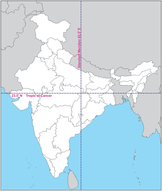
Standard Meridian of India: Quick Facts (NCERT Class 9 Geography)
| Feature | Value / Details |
|---|---|
| Standard Meridian Longitude | 82°30′E (82°30′ East Longitude) |
| Reference Place in India | Mirzapur (near Prayagraj, Uttar Pradesh) |
| Time Zone Name | Indian Standard Time (IST) |
| Difference from GMT / UTC | +5 hours 30 minutes (82.5 × 4 minutes = 330 minutes) |
| Westernmost & Easternmost Longitudes of India | 68°7′E (Gujarat) to 97°25′E (Arunachal Pradesh) |
| Number of Indian States Crossed | 5 States (UP, MP, Chhattisgarh, Odisha, Andhra Pradesh) |
Which 5 States Does the Standard Meridian of India Pass Through?
Moving from north to south, the Standard Meridian of India (82°30′E) passes through five Indian states:
- Uttar Pradesh (passes through Mirzapur)
- Madhya Pradesh (passes through Singrauli district)
- Chhattisgarh (passes through Koriya / Surajpur / Korba region)
- Odisha (passes through Nuapada / Nabarangpur / Koraput region)
- Andhra Pradesh (passes through Kakinada / Yanam region before entering the Bay of Bengal)
Easy Memory Trick (Mnemonic): Remember “UMA CO” — Uttar Pradesh, Madhya Pradesh, Andhra Pradesh, Chhattisgarh, Odisha.
Why Is 82°30′E Chosen as the Standard Meridian of India?
This is one of the most important questions from NCERT Class 9 Geography Chapter 1 (India – Size and Location):
- 30° Longitudinal Extent (2-Hour Time Lag): India’s mainland extends from 68°7′E in Gujarat in the west to 97°25′E in Arunachal Pradesh in the east—a longitudinal span of nearly 30 degrees.
- 4 Minutes per Degree Calculation: Since the Earth rotates 1° of longitude every 4 minutes, a 30° difference causes a local time lag of 30 × 4 = 120 minutes (2 hours) between the easternmost and westernmost parts of India.
- Exact Central Longitude: To avoid confusion in train schedules, flights, offices, and broadcasts across the country, the central meridian midway between 68°7′E and 97°25′E—namely 82°30′E—was chosen as India’s single Standard Meridian.
- Divisible by 7°30′ (Half-Hour International Convention): By international agreement, standard meridians are chosen in multiples of 7°30′ (30 minutes of time). Since 82°30′ = 11 × 7°30′, Indian Standard Time is exactly 5 hours 30 minutes ahead of GMT.
Frequently Asked Questions on the Standard Meridian of India
Which is the Standard Meridian of India?
The longitude of 82°30′E (82 degrees 30 minutes East) is the Standard Meridian of India. Its local time is followed across the entire country as Indian Standard Time (IST), which is 5 hours 30 minutes ahead of GMT.
From where does the Standard Meridian of India pass in Uttar Pradesh?
The Standard Meridian of India (82°30′E) passes through Mirzapur in Uttar Pradesh, which is used as the official reference location for Indian Standard Time.
Which are the five states through which the Indian Standard Meridian passes?
In north-to-south order, the Standard Meridian of India passes through five states: Uttar Pradesh, Madhya Pradesh, Chhattisgarh, Odisha, and Andhra Pradesh.